Louisville is a great city to capture beautiful and stunning photographs. You just have to go out and explore Louisville and the surrounding Kentucky countryside, and you will find them.
If you are new to Louisville, or if you have been in Louisville for a while but are new to photography, or if you are just visiting and have some time to explore with your camera, you may be wondering "Where do I start?" We can certainly help you with that as we get asked all the time, "Where is a good place to take photographs in Louisville?" So, we made a list of some of our favorite places. This list isn't all-inclusive, and there are certainly many photogenic places in Louisville that are not on our list — we are just offering a sampling, a quick list to get you started.
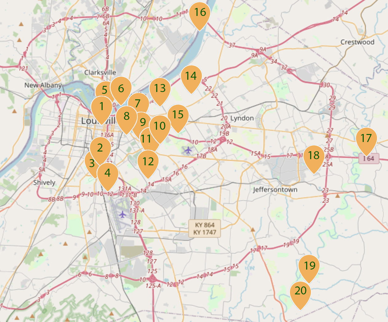
We start with a map below that gives you an overview of Louisville. We have created 20 groups of suggested locations to get you started on your Louisville photography adventure (40 photogenic locations in all). The overview map below shows you what part of town the location is in so you can plan your photo outing.
Each location listed includes a photo, an address or directions, and at the start of each location are the location's GPS coordinates for where the photograph shown was actually taken. You can click on the GPS coordinates to view a larger street map. Some of the areas mentioned below may actually extend for several blocks. You can copy and paste the GPS coordinates into Google on your smart phone, select directions, and your phone will lead you straight there. We have tried to make it as easy as we can for you to navigate and explore. Happy shooting!
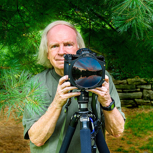
All photos copyright John Hultgren.
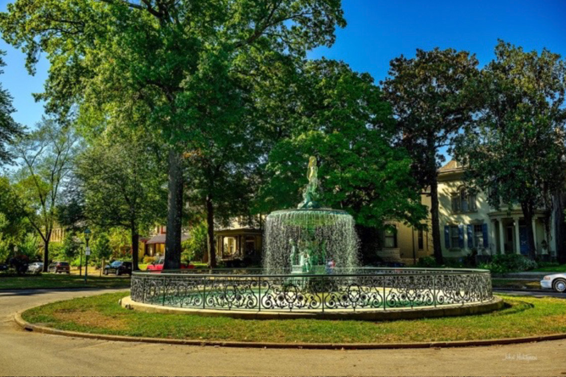
1 GPS: N 38°13.6845', W 085°45.7928'
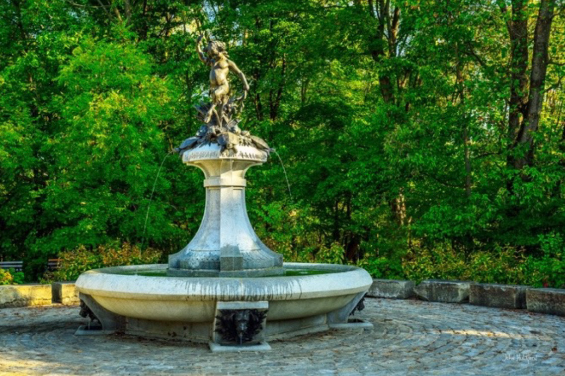
Saint James Court Fountain
Old Louisville Neighborhood
1430 St. James Court, Louisville
The St. James–Belgravia Historic District, within Old Louisville, was placed on the National Register of Historic Places in 1972. It comprises St. James Court (north) and Belgravia Court (south). It is bordered to the north by Louisville's Central Park. The area was the site of the Southern Exposition, a World's Fair-like event held from 1883 to 1887, and the neighborhood hosts the St. James Court Art Show which takes place annually the first weekend of October. The St. James Court Art Show is consistently top-rated, having been ranked as one of the top 10 art shows in the nation by Sunshine Artist Magazine.
St. James Court is known for its elegant, tree-lined streets and beautiful, large Victorian homes. Gas lamps still flicker at night. The St. James Court Fountain is a historic bronze fountain, originally installed around 1895 and replaced in the 1970s, and the fountain is a centerpiece of the St. James Court Art Show. There are plenty of beautiful buildings and items to photograph in this location. Street parking is available and it is a neighborhood with no admission fee.
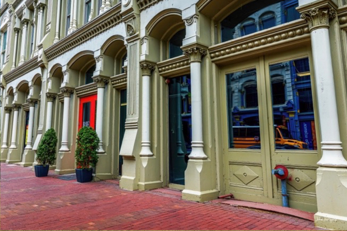
1 GPS: N 38°15.4380', W 085°45.7746'
Louisville Cast-Iron Architecture
730 West Main Street, Louisville
The West Main District of Louisville is one of five downtown districts, with a portion listed in the National Register of Historic Places because it contains some of the oldest structures in the city. It also boasts the largest collection of cast iron façades of anywhere outside of New York City's SoHo district. Louisville's best example of cast-iron architecture stands at 726-730 West Main Street, designed by architect Charles D. Meyer in 1884 for the Hart Hardware Company. Cast-iron components were popular during the late nineteenth century and offered many advantages over masonry. Mass-produced cast iron was less expensive to work with than stone, and the casting process enabled complex patterns and ornamentation to be incorporated into building components with relative ease and at a minimal cost. Cast iron is lighter and stronger than masonry and takes up less wall space, permitting much larger windows that created better interior lighting during the pre-electricity era. Builders also did not automatically need to hire an architect. Metered street parking is available, along with paid parking lots. Most of the downtown streets a few blocks south of Broadway are not metered.
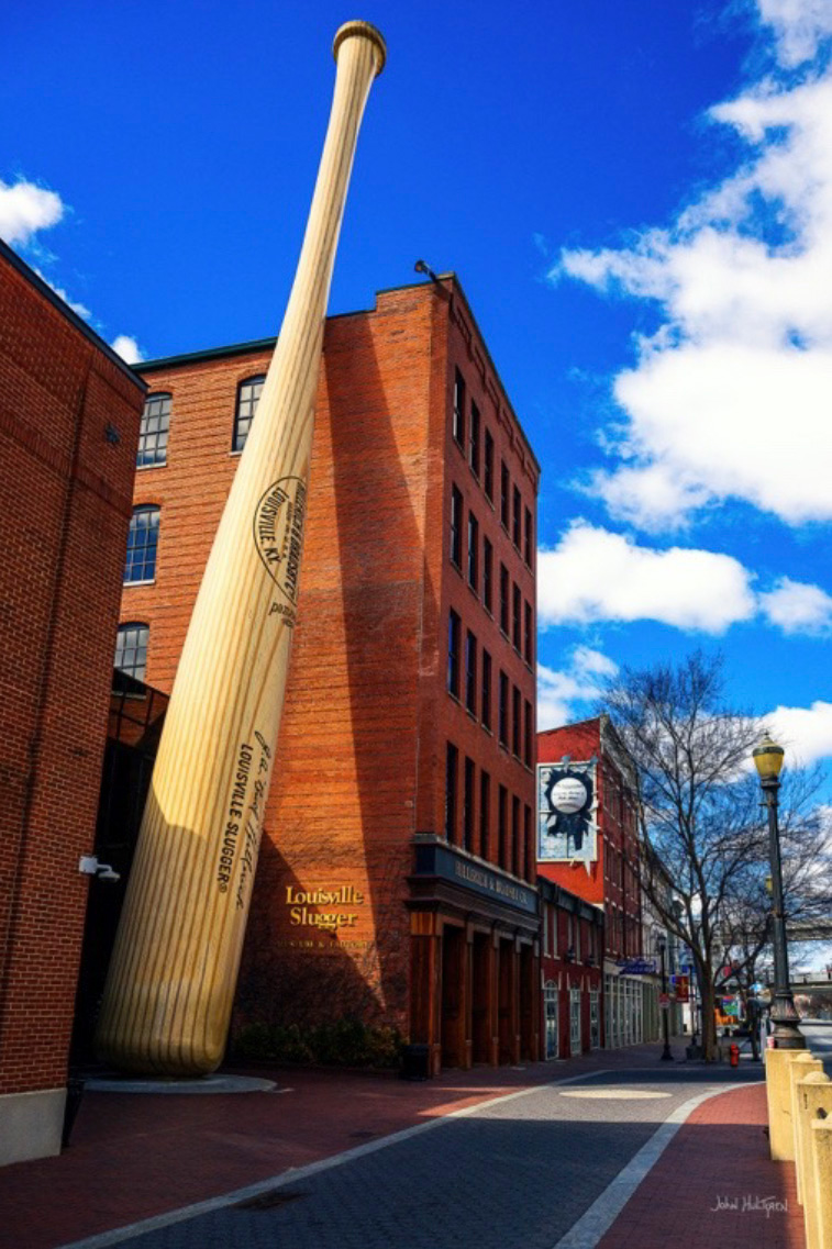
1 GPS: N 38°15.4391', W 085°45.8255'
Louisville Slugger Museum
Museum Row, West Main District
800 W. Main St., Louisville
The Louisville Slugger Museum & Factory is a museum and factory tour attraction located in Louisville's "Museum Row", part of the West Main District of downtown. The museum showcases the story of Louisville Slugger baseball bats in baseball and in American history. The museum features the World's Largest Baseball Bat, positioned outside, which is listed in the Guinness World Records for being the largest baseball bat is 120 ft. tall and weighing 68,000 pounds. You can photograph the baseball bat in front of the museum from the street. Metered street parking is available, along with paid parking lots. Most of the downtown streets a few blocks south of Broadway are not metered.
1 GPS: N 38°15.4405', W 085°45.7588'
Kentucky Science Center
727 W. Main St., Louisville
The Kentucky Science Center is Kentucky's largest science museum. Located on Louisville's "Museum Row" in the West Main District of downtown, the museum features a large parabolic mirror outside its entrance that is 16-½ feet in diameter, and was originally used to generate power at the world's first commercial solar power plant in Australia. The mirror is outside the building next to the sidewalk, and you can walk up to the mirror and photograph it without the museum entry fee. This is a fun place to take photos of your children. Metered street parking is available, along with paid parking lots. Most of the downtown streets a few blocks south of Broadway are not metered.

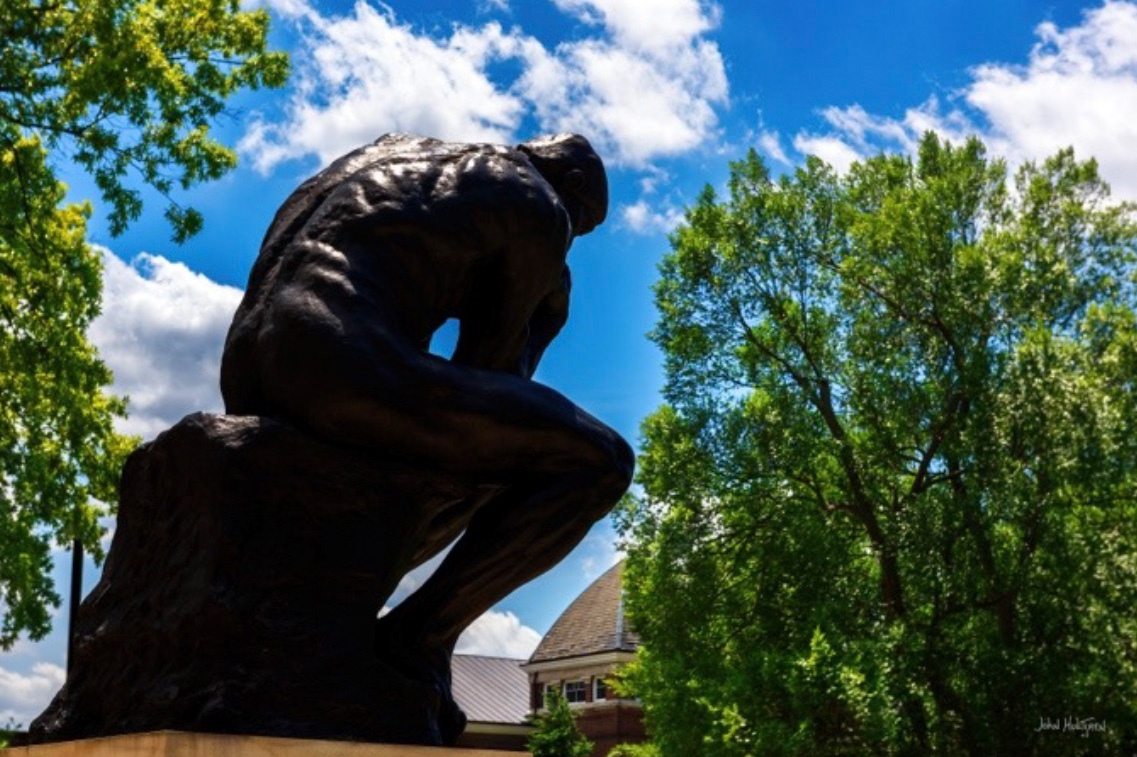
2 GPS: N 38°12.9111', W 085°45.6261'
The Thinker
Grawemeyer Hall, University of Louisville,
2301 S 3rd St, Louisville
The University of Louisville has a large bronze cast of Auguste Rodin's "The Thinker", which was first displayed at the 1904 World's Fair and given to the city of Louisville in 1949 by the Hillman-Hopkins family. The statue has been on the University of Louisville's Belknap Campus since it arrived in 1949, originally in front of the main administration building (now Grawemeyer Hall). It is a monumental casting of the original sculpture, and the university's version is the first one cast by the founder A. A. Hébrard. Off-campus street parking is available.
2 GPS: N 38°13.9155', W 085°45.8591'
The Witches' Tree
Old Louisville
Corner of Sixth Street and Park Avenue, Louisville
The Witches’ Tree is a local Louisville folklore landmark. A maple tree once stood in this spot, which was the favored meeting place for those involved with the dark arts. In 1889, Louisville’s planning committee wanted to use the maple tree as a May pole for the May Day Celebration. According to legend, witches warned the city that if they cut down the tree, there would be a price to pay, but the committee chopped it down anyway. Eleven months later to the day, the legend goes that the witches brewed a “demon” of a vengeful storm, and as the tornado tore through the city, a bolt of lightning hit the stump and sprouted the twisted, gnarled tree that stands there today. Street parking is available.
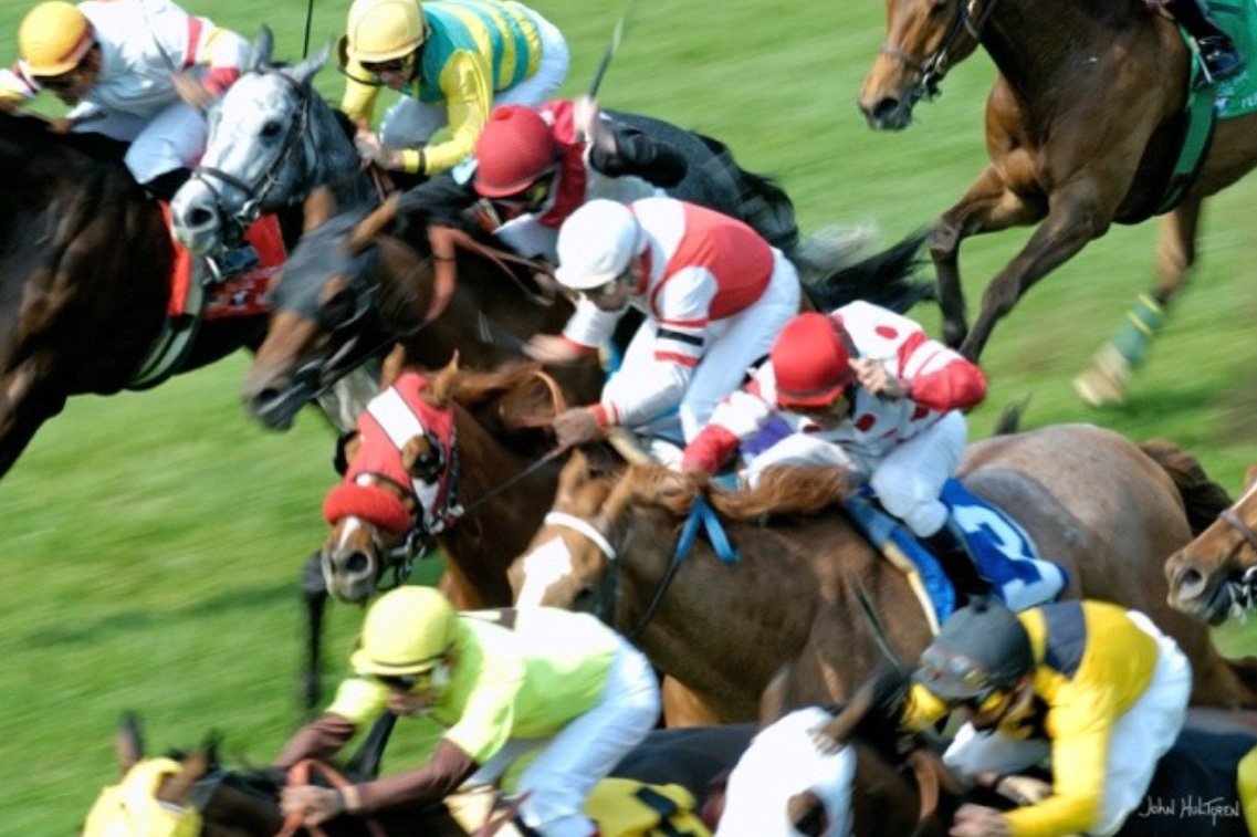
3 GPS: N 38°12.2270', W 085°46.2020'
Churchill Downs
700 Central Avenue, Louisville
Churchill Downs is a horse racing complex in Louisville that also hosts the annual Kentucky Derby. It opened in 1875 and was named after the Churchill family, prominent in Kentucky for many years. You can visit Churchill Downs for free on select special event days like "Dawn at the Downs" or "College Day," and you can watch horses work out for free during "Dawn at the Downs" mornings. For general racing days, a ticket is required for entry, though some events may offer free general admission with a valid college ID or include free parking. For regular racing days, you must purchase a general admission ticket, which starts at around $10. Parking at Churchill Downs is often free, with specific lots like the Yellow, Blue, Orange, Turquoise, and Green lots available for free on a first-come, first-served basis during many events. However, paid parking can apply to premium events, with prices varying by event, location, and type of vehicle. At the time of publication, in most cases cameras with detachable lenses or with a lens that is 6 inches or larger are prohibited.
4 GPS: N 38°11.8800', W 085°44.7430'
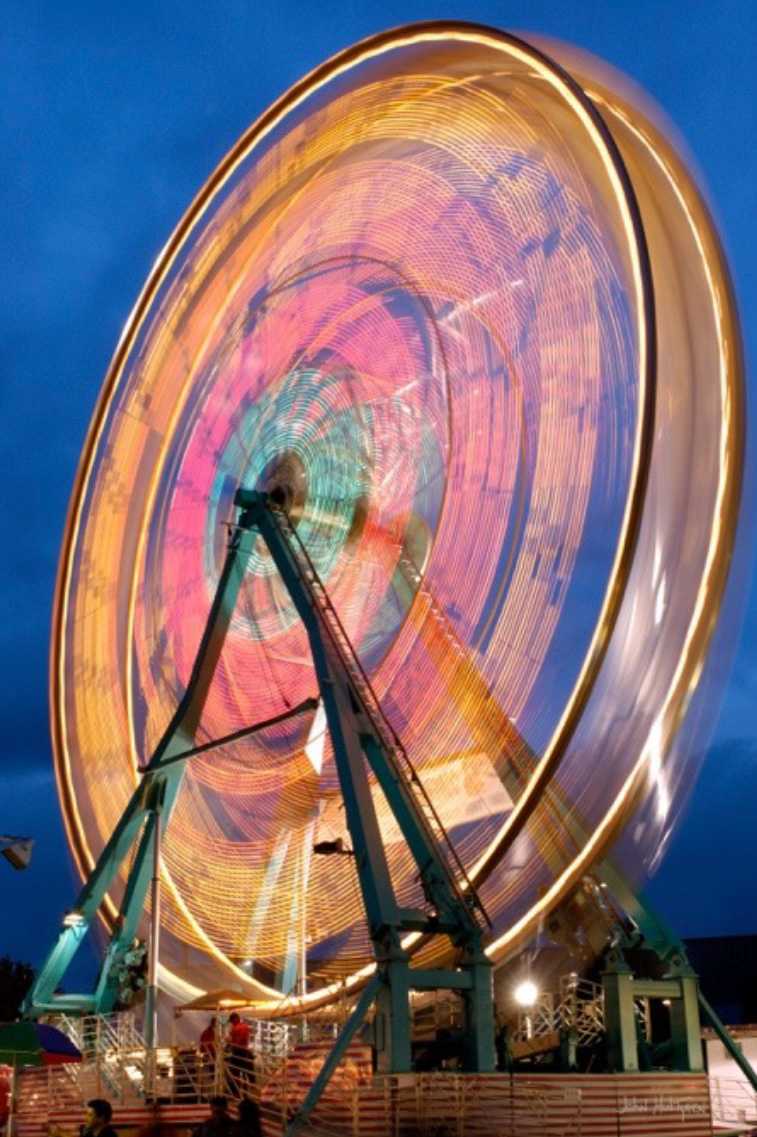
Kentucky State Fair
Kentucky Exposition Center, 937 Phillips Lane, Louisville
The Kentucky State Fair is the official state fair of Kentucky which takes place at the Kentucky Exposition Center in Louisville. More than 600,000 fairgoers fill the 520 acres of indoor and outdoor exhibits; activities include sampling a wide variety of food and riding several roller coasters during the 11-day event. The Kentucky State Fair includes competitions in crafts such as quilt-making, homebrew beers, and home-made pastries, as well as fine arts (which includes photography) and agricultural competitions. At the time of publication, admission to the Kentucky State Fair costs $12 online (which includes free parking) or $10 at the gate (which does not include parking, which costs an additional $10). Special discount days, like Military Sunday and Senior Day, are also available, and advance tickets through certain locations like Kroger were cheaper before a certain date. Cameras are allowed at the Kentucky State Fair for personal use, but commercial photography and videography require prior written approval. You can bring a standard camera to take photos of the exhibits, people, and entries without any issues. Good places to take photos at the fair include the animal exhibits, the horse show, the competitions, and the midway with all of the amusement rides.
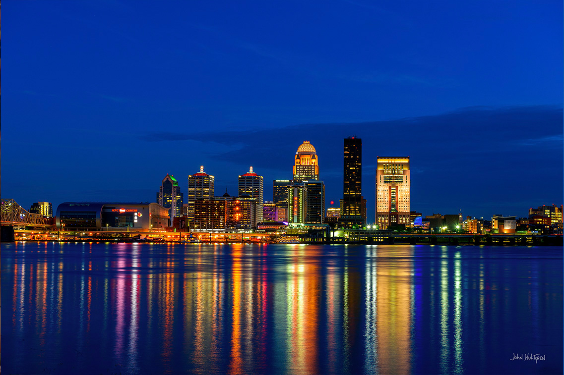
5 GPS: N 38°16.2248', W 085°45.3486'
Louisville Skyline
Ashland Park, 430 East Riverside Drive, Clarksville, Ind.
Ashland Park is a short drive from Louisville's Second Street Bridge, which in not a toll bridge. Free parking is available in the park. Restroom facilities are also available. This is a great location for photographing the Louisville skyline, and you can walk right up to the river, but it gets crowded during special events.
5 GPS: N 38°16.11950', -085°44.36870'
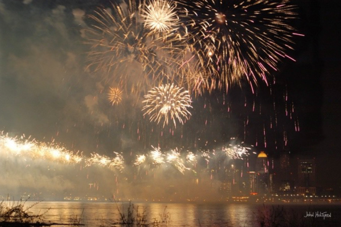
Thunder Over Louisville
Ashland Park, 430 East Riverside Drive, Clarksville, Ind.
Thunder Over Louisville is the official kickoff event for the Kentucky Derby Festival, which includes the largest annual fireworks show in the United States and one of the country's top air shows. The event takes place in Louisville along the waterfront and it is a massive spectacle that features military and civilian aircraft, fireworks, and other activities on the ground, such as food vendors, music, and games. Thunder is typically held two weeks before the Kentucky Derby, which is the first Saturday in May. This makes the event take place on a Saturday in mid-to-late April. In years when Easter falls on the same weekend as the usual date, the event is moved up a week earlier. Thunder generally starts in the afternoon with an air show, followed by the fireworks show from 9:30 pm until 10.
There are multiple locations where you can view the air show and the fireworks in Louisville, on both sides of the river. One of those options is Ashland Park, across the river in Clarksville, Indiana, which is a short drive from Louisville's Second Street Bridge, which in not a toll bridge, and this location offers the Louisville skyline as a backdrop. Free parking is available in the park but space will be hard to secure due to the crowd. Free parking is usually available along streets within walking distance. Restroom facilities are also available.
Because of the crowds, it is recommended that you arrive early. I typically bring a lawn chair and set my tripod up in the river so that people will not be walking in front of my camera. It is highly recommended that you attend the event with someone else who can watch your spot and your equipment while you use the restroom, and you should bring snacks as it will be a long day.
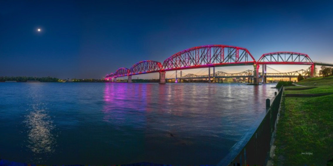
6 GPS: N 38°16.1195', W 085°44.3687'
Big Four Pedestrian Bridge
Van Dyke Park, 331 W Riverside Dr., Jeffersonville, Ind.
The Big Four Bridge is a six-span truss bridge that crosses the Ohio River, connecting Louisville and Jeffersonville, Indiana. It was completed in 1895 and rebuilt in 1929. It was taken out of rail service in 1968, and the original approaches that carried rail traffic onto the main spans were first removed in 1974–1975. It was converted to bicycle and pedestrian use in 2013. The bridge is lit in the evenings and nighttime. There are multiple opportunities to photograph the bridge from both sides of the river, with Jeffersonville's Van Dyke Park being one option. There are multiple free parking lots within Waterfront Park. Waterfront Park does not have an admission fee.
This photo was shot during the Blue Hour as a panoramic image consisting of four photos taken vertically and stitched together. I had parked at Waterfront Park and walked across the bridge to the Van Dyke Park.
7 GPS: N 38°15.8195', W 085°43.2144'
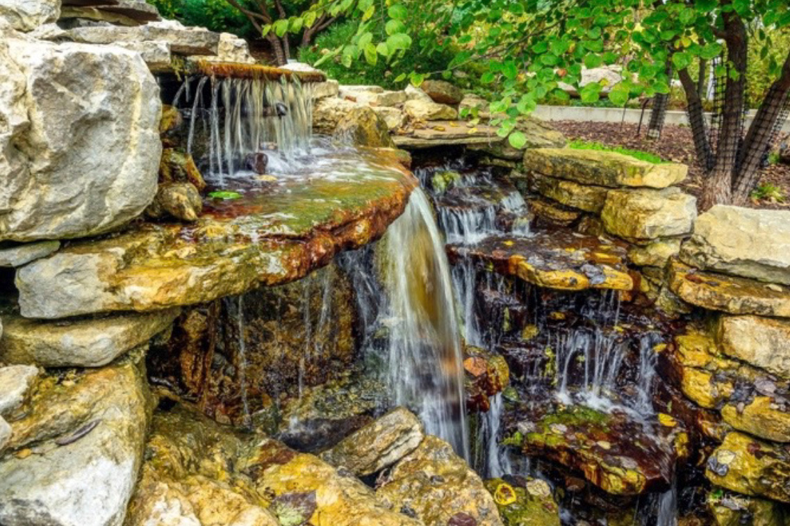
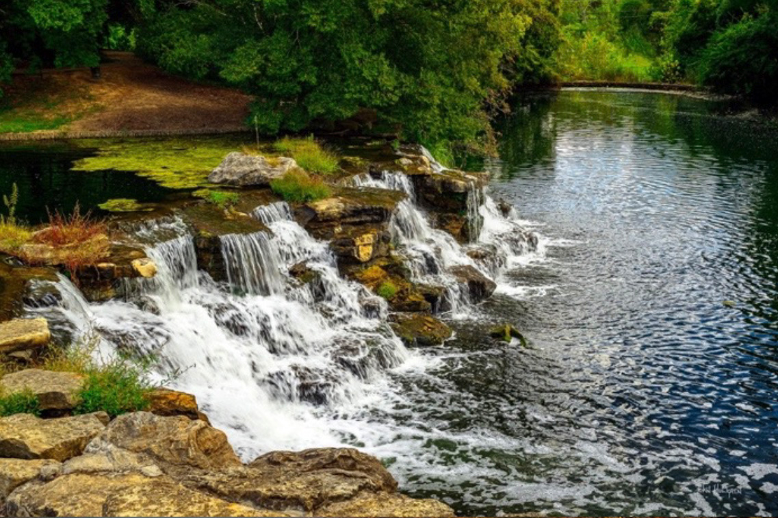
Waterfront Botanical Gardens Waterfall
Waterfront Botanical Gardens
1435 Frankfort Ave., Louisville
The Waterfront Botanical Gardens is an urban botanical garden in Louisville. The botanical garden occupies 23 acres in the Butchertown neighborhood east of Downtown Louisville along Beargrass Creek. It was built on top of a former municipal landfill, so the waterfall is man-made. It was planned to be built in phases. There is a $10 suggested admission fee though it is free for members and the gardens are open to the public. They have two free parking lots.
7 GPS: N 38°15.7283', W 085°44.2058'
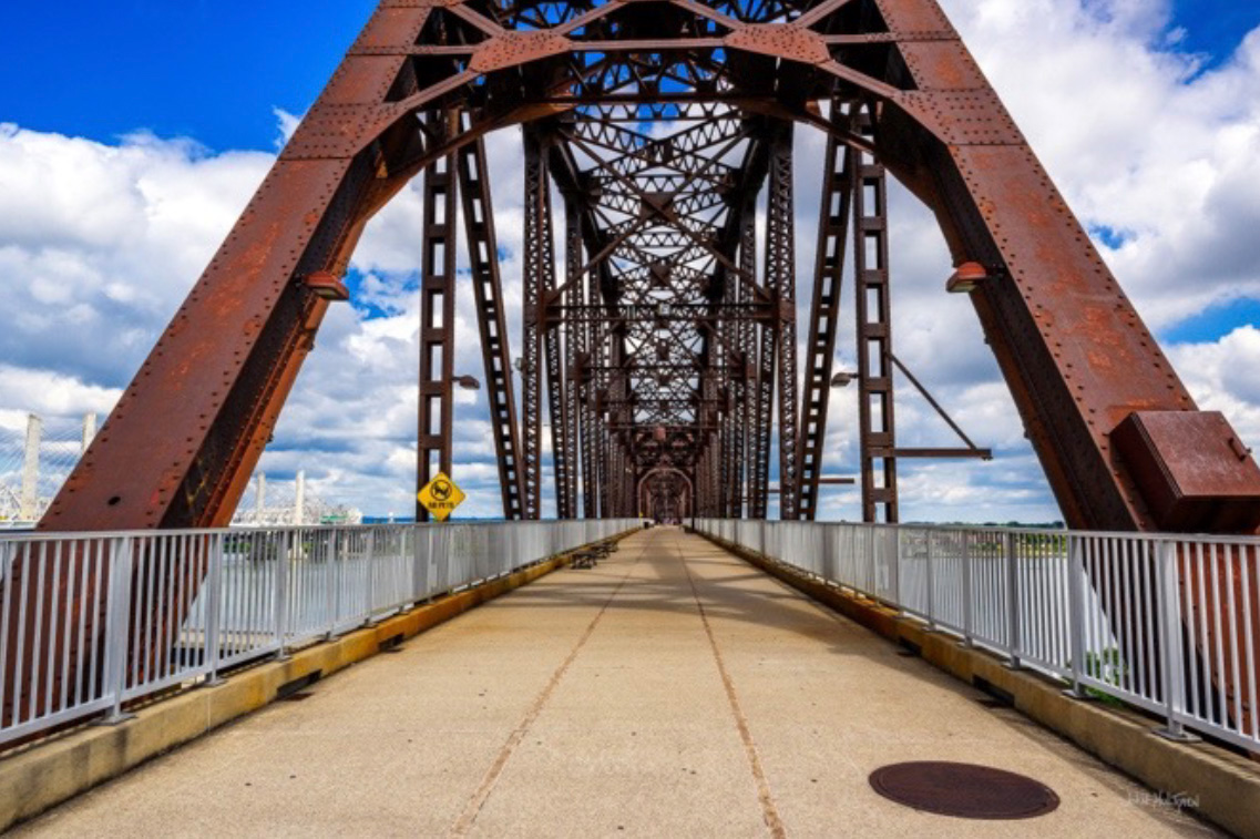
Big Four Pedestrian Bridge
Waterfront Park
1101 River Road, Louisville
The Big Four Bridge is a six-span truss bridge that crosses the Ohio River, connecting Louisville and Jeffersonville, Indiana. It was completed in 1895 and rebuilt in 1929. It was taken out of rail service in 1968, and the original approaches that carried rail traffic onto the main spans were first removed in 1974–1975. It was converted to bicycle and pedestrian use in 2013. The bridge is a good place for street photography and for photographing river traffic, particularly with the Louisville skyline in the background. There are multiple free parking lots within Waterfront Park. Waterfront Park does not have an admission fee.
7 GPS: N 38°15.8368', W 085°43.5151'
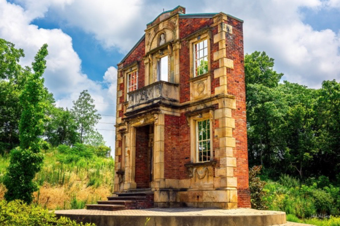
Heigold House Façade
332 Frankfort Avenue, Louisville
The Heigold House facade is the only surviving part of a 19th-century home built by German immigrant stonemason Christian Heigold in Louisville, KY. Originally built in 1857, the house was demolished in 1953 to make way for a city dump. The facade, however, was saved due to its historical significance and is now a landmark at the intersection of Frankfort Avenue and River Road. The facade is famous for its intricate stone carvings, which include patriotic sayings, busts of American presidents like George Washington and James Buchanan, and images of Heigold's family, all intended to display his loyalty to the United States during a time of anti-immigrant sentiment. Street-side parking, and open to the public.
7 GPS: N 38°15.7949', W 085°44.2558'
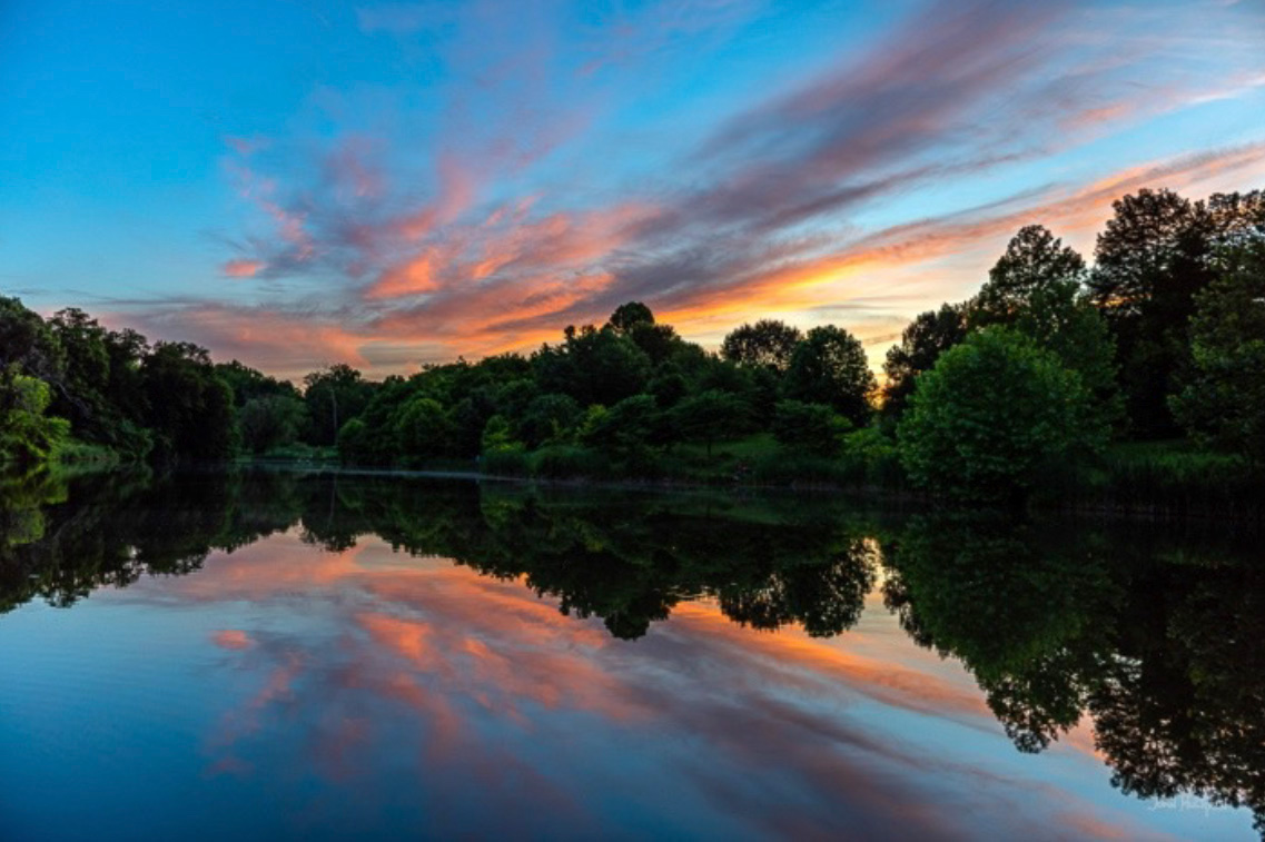
Louisville Riverfront
Waterfront Park, Big Four Pedestrian Bridge
1101 River Road, Louisville
The Louisville Riverfront can be photographed from many locations, including downtown Louisville along Waterfront Park, the Big Four Pedestrian Bridge, the Second Street Bridge, and parks on the Indiana side of the Ohio River. This photo was taken from the Big Four Pedestrian Bridge using the sunset and the Interstate bridges as the background.

8 GPS: N 38°15.0140', W 085°43.8410'
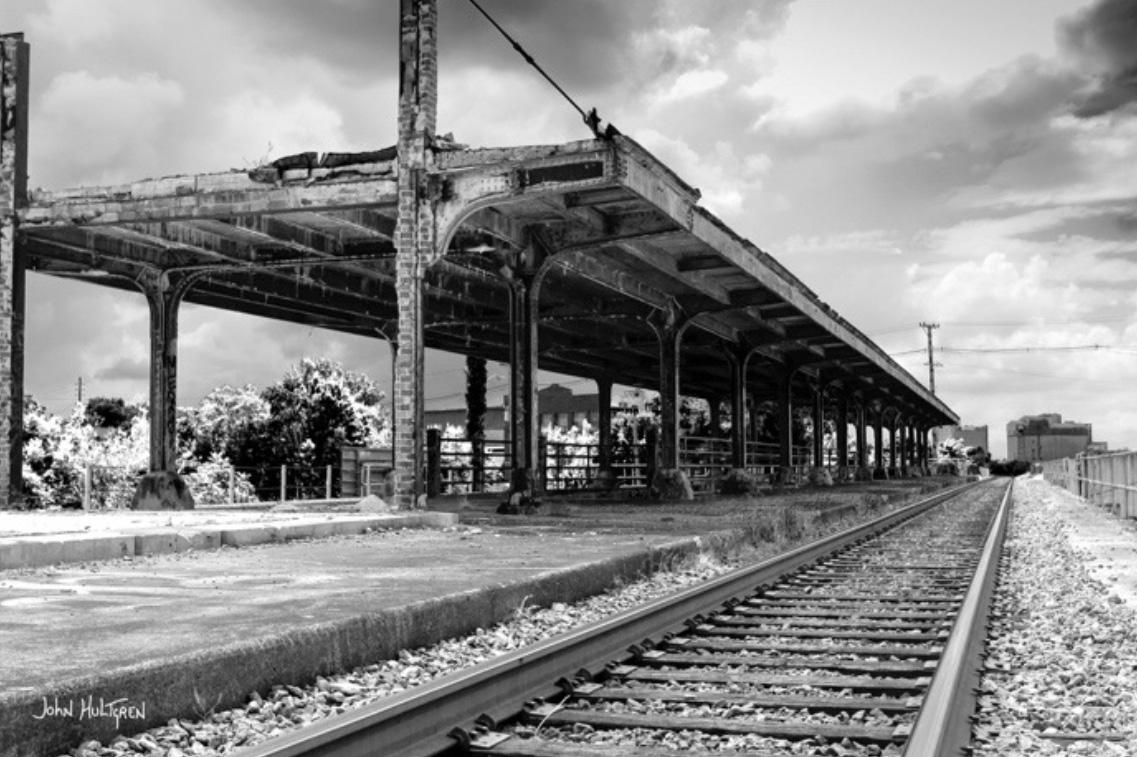
Old Baxter Avenue Elevated Train Station
Located on the elevated railroad line approximately 500 feet east of the intersection of Baxter Ave., East Liberty St., and Lexington Road in Louisville.
The old Baxter elevated train station was demolished in 2009. The buildings for the baggage office, ticket office, and segregated waiting areas were removed but the platform and most of the roof remain.
Please note that it is illegal and dangerous to walk along railroad tracks. Railroad tracks and the surrounding land are private property, and walking on them is considered criminal trespassing, except when crossing at a designated pedestrian or roadway crossing. It is crucial to stay alert and aware of your surroundings, as trains can appear unexpectedly and it is known that houseless populations frequently camp on the ground underneath this structure.
9 GPS: N 38°14.7688', W 085°43.0837'
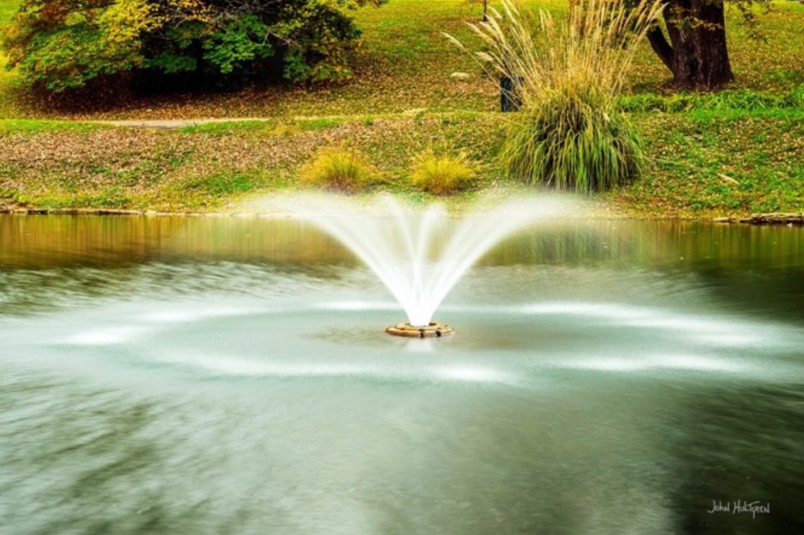
Cave Hill Cemetery Fountain
Cave Hill Cemetery & Arboretum
701 Baxter Ave., Louisville
Cave Hill Cemetery and Arboretum is a 296-acre Victorian-era national cemetery located in Louisville, Kentucky. It is the largest cemetery by area and number of burials in Louisville, and is listed on the National Register of Historic Places. There are many artistic monuments and statues throughout the cemetery that you can photograph. Open daily from 8:00 a.m. to 4:45 p.m., weather permitting, and parking is only allowed on paved surfaces. You can take photographs at Cave Hill Cemetery, but commercial photography requires prior written permission from the main office. Casual and landscape photography are permitted, but you must always be respectful, avoid taking pictures of recent funerals or grieving visitors, and follow all cemetery rules such as the speed limit and avoiding parking on the grass.
9 GPS: N 38°14.5540', W 085°42.7324'
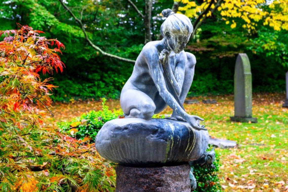
Cave Hill Statue
Cave Hill Cemetery & Arboretum
701 Baxter Ave., Louisville/p>
Cave Hill Cemetery and Arboretum is a 296-acre Victorian-era national cemetery located in Louisville, Kentucky. It is the largest cemetery by area and number of burials in Louisville, and is listed on the National Register of Historic Places. There are many artistic monuments and statues throughout the cemetery that you can photograph. Open daily from 8:00 a.m. to 4:45 p.m., weather permitting, and parking is only allowed on paved surfaces. You can take photographs at Cave Hill Cemetery, but commercial photography requires prior written permission from the main office. Casual and landscape photography are permitted, but you must always be respectful, avoid taking pictures of recent funerals or grieving visitors, and follow all cemetery rules such as the speed limit and avoiding parking on the grass.
9 GPS: N 38°14.8747', W 085°43.2271'
Cave Hill National Cemetery
701 Baxter Ave., Louisville
Cave Hill National Cemetery is a section within the larger, privately owned Cave Hill Cemetery and Arboretum. The national cemetery is situated in the northwest corner of the property, and the Cave Hill Cemetery Company donated the land for the national burials in 1861. The national cemetery was established during the Civil War for the interment of Union soldiers and now includes veterans from later conflicts. While the national cemetery is a federal property, it is located on land owned by the Cave Hill Cemetery Company. Open daily from 8:00 a.m. to 4:45 p.m., weather permitting, and parking is only allowed on paved surfaces. There are many artistic monuments and statues throughout the cemetery that you can photograph. You can take photographs at Cave Hill Cemetery, but commercial photography requires prior written permission from the main office. Casual and landscape photography are permitted, but you must always be respectful, avoid taking pictures of recent funerals or grieving visitors, and follow all cemetery rules such as the speed limit and avoiding parking on the grass.

9 GPS: N 38°14.8063', W 085°43.2006'
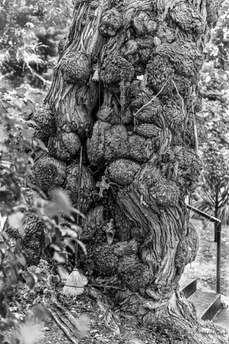
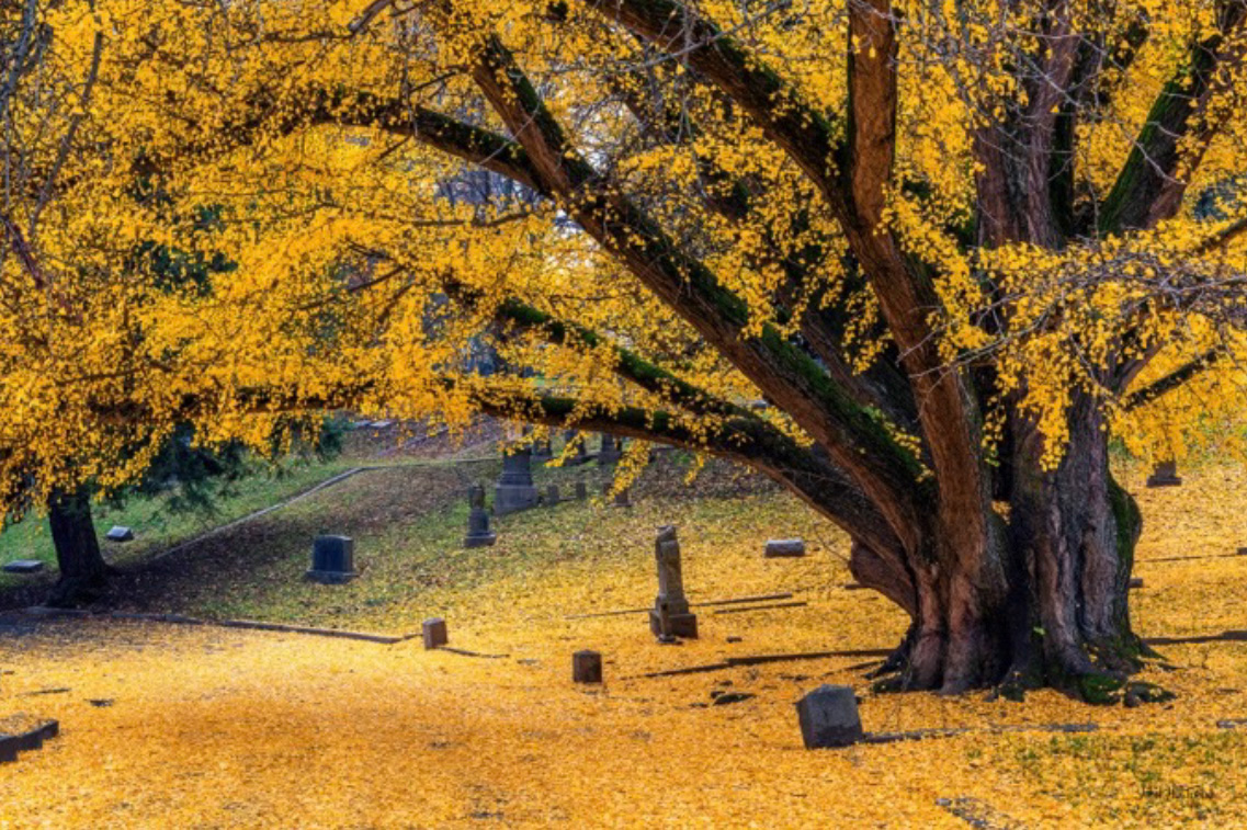
Cave Hill Cemetery Ginkgo Tree
Cave Hill Cemetery & Arboretum
701 Baxter Ave., Louisville
The ginkgo tree in Section N is arguably one of the most beautiful and intriguing trees in Cave Hill Cemetery and Arboretum. Cemetery lore says that in the 1840s, the tree was gifted to Henry Clay from the Emperor of Japan or Japanese ambassador, who presented Clay with a packet of “Tree of Heaven” seeds. Clay planted several ginkgoes at Ashland, his home in Lexington, and he gave one to James Brown to plant on Wildwood Farm in St. Matthews, and one to Cave Hill Cemetery. Ginkgo leaves fall in the late autumn, typically all at once after a hard frost. The tree forms a special abscission layer that causes all the leaves to detach and fall on the same day.
Cave Hill Cemetery and Arboretum is a 296-acre Victorian-era national cemetery located in Louisville, Kentucky. It is the largest cemetery by area and number of burials in Louisville, and is listed on the National Register of Historic Places. There are many artistic monuments and statues throughout the cemetery. Open daily from 8:00 a.m. to 4:45 p.m., weather permitting, and parking is only allowed on paved surfaces. There are many artistic monuments and statues throughout the cemetery that you can photograph. You can take photographs at Cave Hill Cemetery, but commercial photography requires prior written permission from the main office. Casual and landscape photography are permitted, but you must always be respectful, avoid taking pictures of recent funerals or grieving visitors, and follow all cemetery rules such as the speed limit and avoiding parking on the grass.

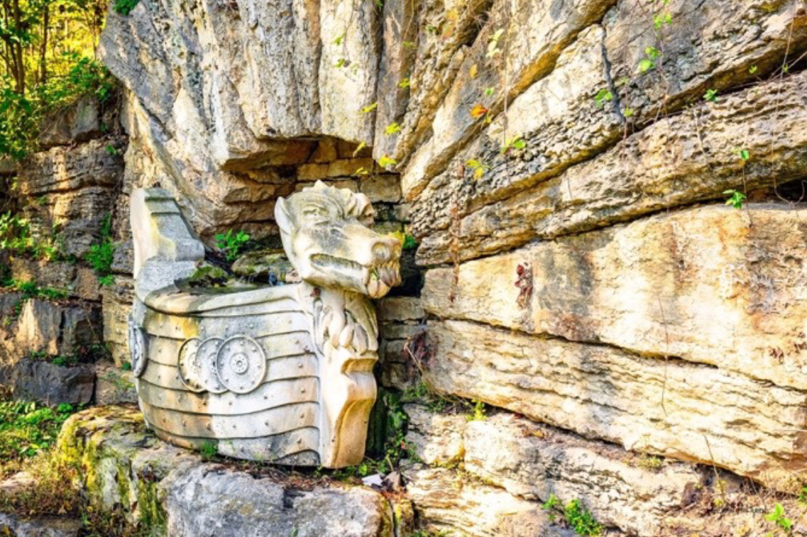
10 GPS: N 38°14.5621', W 085°42.0054'
Christensen Fountain
Cherokee Park, 745 Cochran Hill Rd, Louisville
The Christensen Fountain was given to the City of Louisville by Margarethe Christensen in honor of her late mother, Paulina Christensen. The fountain is modeled after a Viking ship and includes the Danish coat of arms in honor of the family’s country of origin. Cherokee Park is a public park open from 6 a.m. to 11 p.m. daily. Parking is available adjacent to the fountain.
10 GPS: N 38°14.3605', W 05°41.7884'
Hogan's Fountain
Cherokee Park
3110 Scenic Loop, Louisville
Hogan’s Fountain in Cherokee Park was created between 1903-1904 by Louisville sculptor Enid Yandell with the intent to be a watering hole for horses and dogs. Cherokee Park is a public park open from 6 a.m. to 11 p.m. Parking is available near the fountain.
10 GPS: N 38°14.0030', W 085°41.0641'
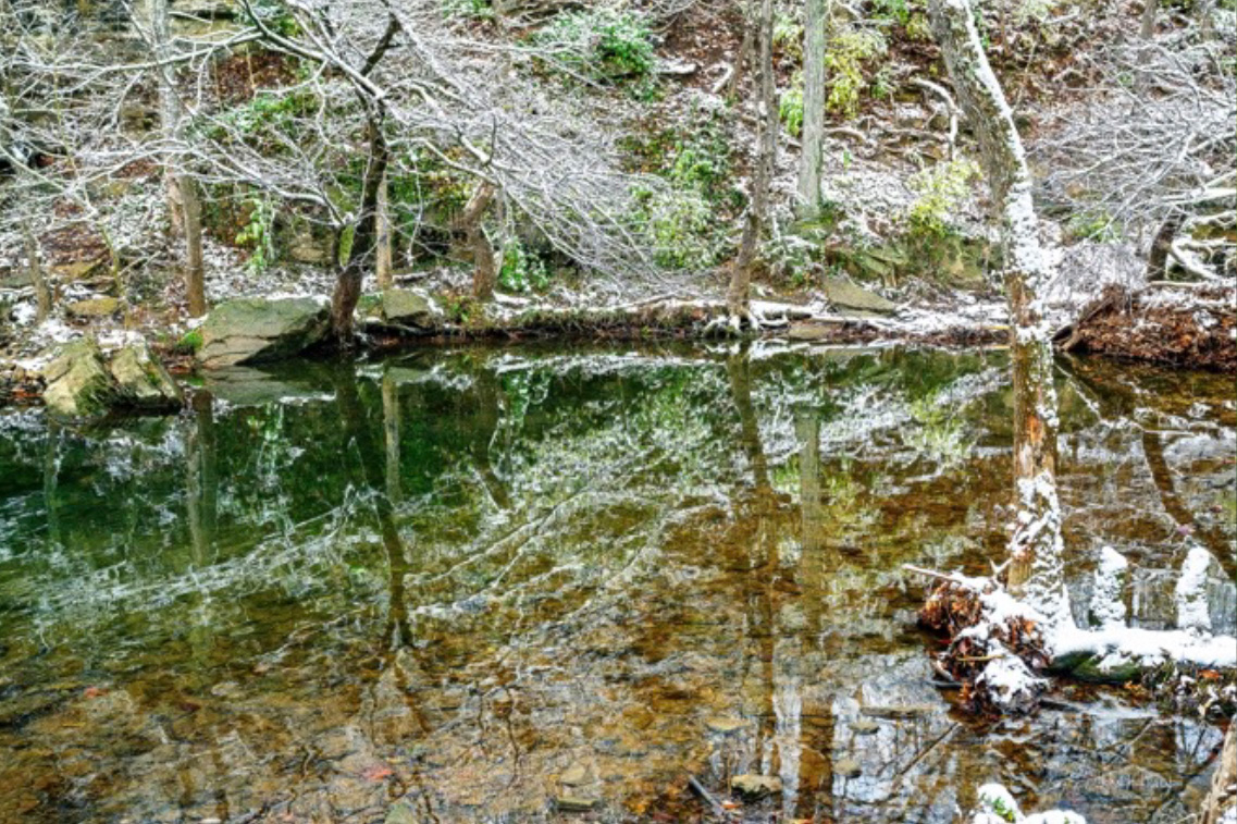
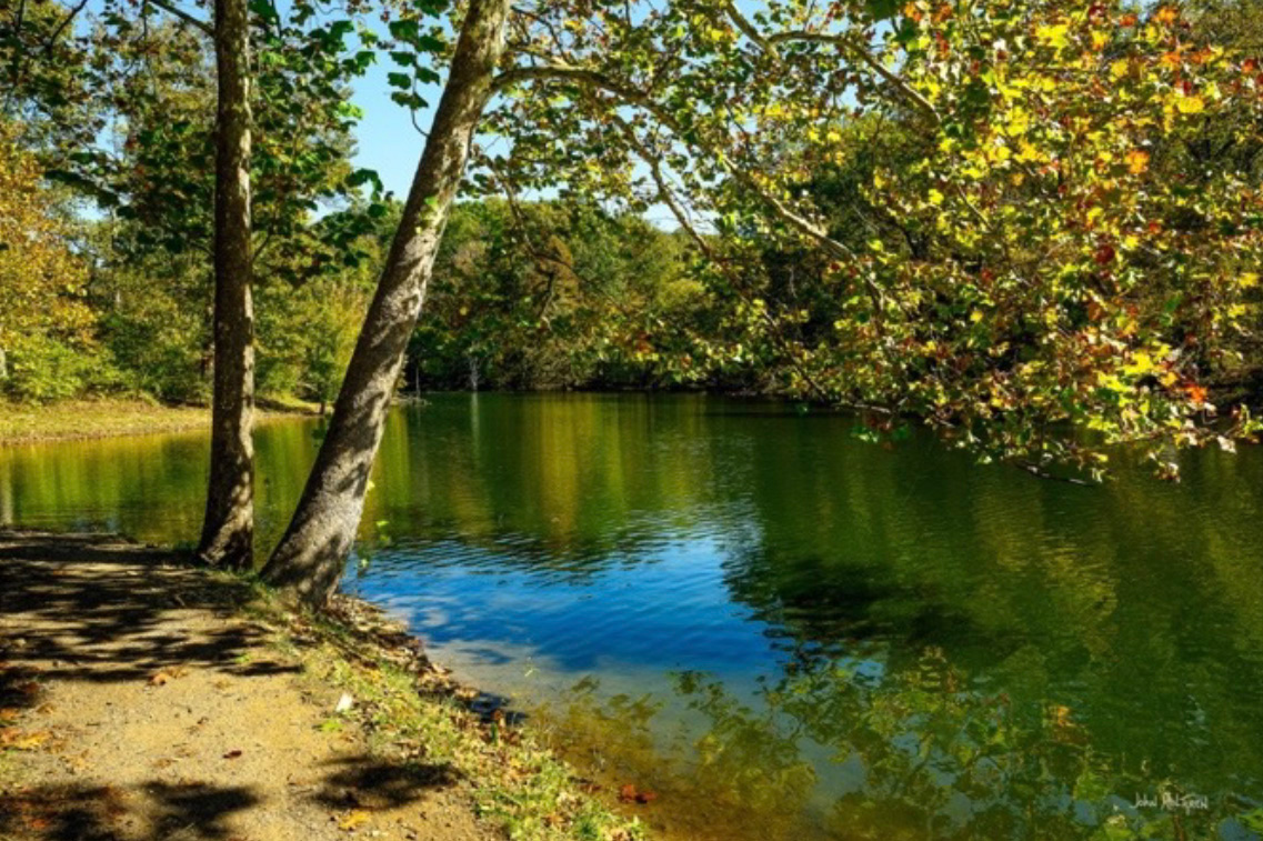
Beargrass Creek
Cherokee Park
2199 Park Boundary Rd, Louisville
Cherokee Park is a 409-acre municipal park located in Louisville and it is part of the Louisville Olmsted Parks Conservancy. It was designed in 1891 by Frederick Law Olmsted, the father of landscape architecture, along with another 18 of Louisville's 123 parks. Beargrass Creek runs through much of the park, and is crossed by numerous pedestrian and automobile bridges. Beargrass Creek is the name given to several forks of the Louisville creek. There are multiple photogenic locations that can be found along the creek with nearby parking.
10 GPS: N 38°13.9996', W 085°40.8778'
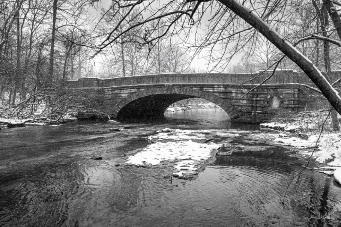
Belknap Memorial Bridge
Cherokee Park
745 Cochran Hill Rd, Louisville
There are numerous stone bridges, likely limestone, in Louisville's Cherokee Park that cross Beargrass Creek, including the Belknap Memorial Bridge. Over the years, additional land, including land from the Belknap family, was added to the park to expand it to its modern size. When Lily Buckner Belknap died in 1893, her husband Col. Morris Burke Belknap constructed the stone bridge in Cherokee Park in her honor. There are two parking lots available near this bridge.
10 GPS: N 38°14.2073', W 085°42.1932'
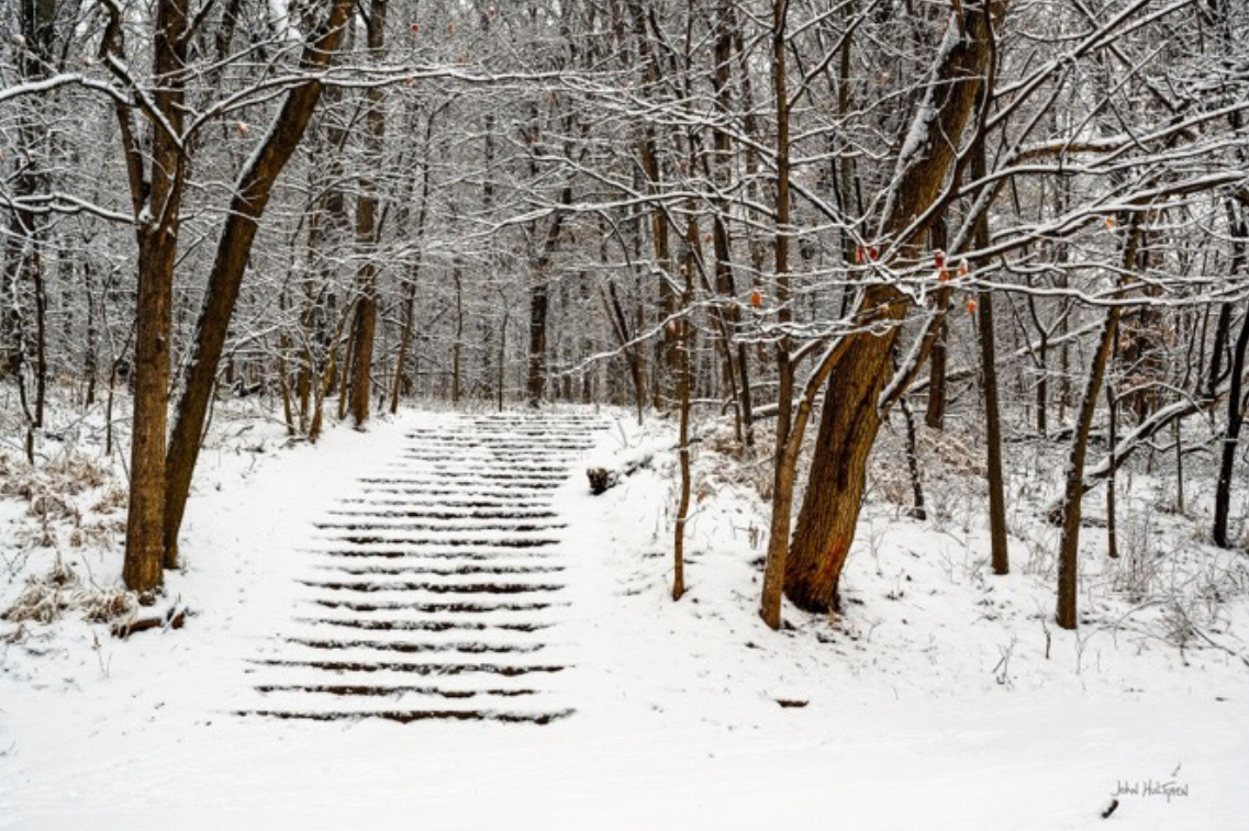
Baringer Steps
Cherokee Park
Scenic Loop, Louisville
The Baringer Steps are stone steps that lead to the Baringer Spring in Louisville's Cherokee Park. The Barringer family farm was located near the park and was developed into homes surrounding the park. Parking is available along Scenic Loop shortly before the steps.
10 GPS: N 38°14.6776', W 085°42.0238'
Willow Pond
Cherokee Park
745 Cochran Hill Rd, Louisville
Willow Pond is a small pond in Louisville's Cherokee Park that was designed by Frederick Law Olmsted in 1891 and is part of the Louisville Olmsted Parks Conservancy. The park offers a scenic, natural setting with amenities like walking paths, playgrounds, and sports fields, and the pond is adjacent to a municipal golf course. It is a nice location to photograph sunsets and fall colors. There are two parking lots close to the pond.
10 GPS: N 38°13.9789', W 085°41.0475'
Big Rock
Cherokee Park
2199 Park Boundary Rd, Louisville
Big Rock is a popular area within Louisville's Cherokee Park, located in Beargrass Creek near the border with Seneca Park. It features a large rock that is a focal point for picnics, wading in the creek, and a playground. The area includes picnic spots, an open shelter building, and connects to the larger Cherokee Park's trails. There are a few parking areas close by that can become crowded during peak recreation times.
While this photo is not of the feature called 'Big Rock,' there are natural cascades along Beargrass Creek just downstream of Big Rock that are fun to photograph, particularly after a rain, so bring your tripod so you can use some slow shutter speeds. This area frequently floods during heavy rain storms.
11 GPS: N 38°13.8938', W 085°42.4571'
Bardstown Road
Deer Park Neighborhood along Bardstown Road, Louisville
Bardstown Road is a main road in Louisville that has a lively and vibrant atmosphere, characterized by a mix of local shops, diverse restaurants, and bars, making it a bustling cultural and commercial hub, particularly in the Highlands area. It can get busy, especially on weekends, and is known for its eclectic mix of independent businesses and a strong sense of community. It is a good location for street photography.
Bardstown Road currently has some parking meters, and in 2025 there is a proposal to add hundreds more along both Bardstown Road and Baxter Avenue. The existing meters are a mix with other parking rules like time limits. I frequently park on the side streets which are not metered.
12 GPS: N 38°12.4167', W 085°42.1577'
Louisville Zoo
Louisville Zoological Gardens
1100 Trevilian Way, Louisville
The Louisville Zoological Gardens is a 134-acre zoo in Louisville, situated in the city's Poplar Level neighborhood. Founded in 1969, the "State Zoo of Kentucky" currently exhibits over 1,200 animals in naturalistic and mixed animal settings representing both geographical areas and biomes or habitats. The Louisville Zoo is accredited by the Association of Zoos and Aquariums and it has eight large exhibits: The Islands, Africa, Glacier Run, Australia, South America, HerpAquarium, Gorilla Forest, and the Cats of the Americas exhibit. Louisville Zoo admission prices vary by age group and season, with adults costing $11-$17, children (3-11) and seniors (60+) costing $8-$14, and children 2 and under getting in for free. Additional costs may apply for special events, and there is a charge for parking. There are a lot of animals and exhibits that can be photographed.
Cameras are allowed at the Louisville Zoo, but you should avoid using flash photography as it can disturb the animals. Tripods are not explicitly mentioned in the rules except for some attractions like the ropes course where they are not permitted. I usually bring along a long lens and a tripod and have never experienced any difficulties, but I am careful to set my tripod up where it is not a tripping hazard.

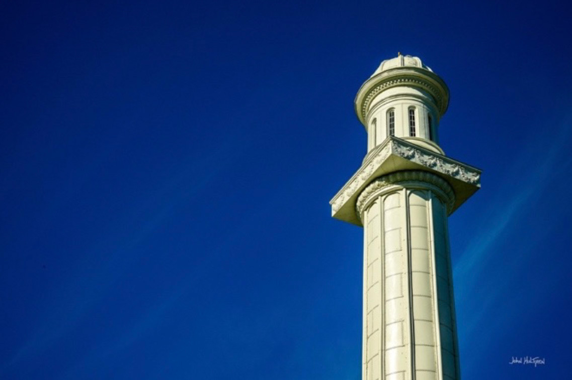
13 GPS: N 38°16.8313', W 085°42.0381'
Louisville Water Tower
3005 River Road, Louisville
The Louisville Water Tower is the oldest ornamental water tower in the world, located near downtown Louisville on the Ohio River. It was built between 1857 and 1860 as part of the city's first waterworks system and is a National Historic Landmark. The original wooden tower was destroyed by a tornado in 1890 and was replaced by the current cast-iron structure. It now houses the WaterWorks Museum.
The cost to tour the Louisville Water Tower and the WaterWorks Museum is between $3 and $5 per person, depending on age. Tickets can be purchased online or at the door. Children under 4 are admitted free. There is free parking and there is no charge to walk around the water tower to photograph it.
13 GPS: N 38°15.4136', W 085°40.6863'
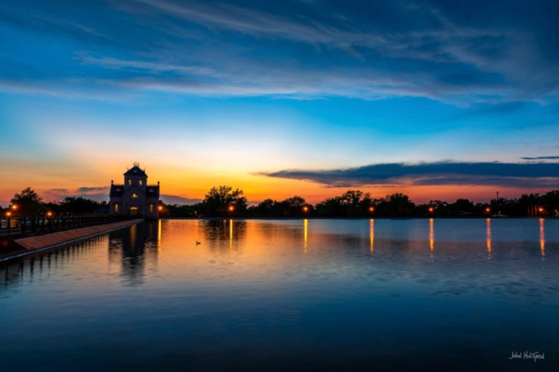
Crescent Hill Reservoir
201 Reservoir Ave, Louisville
The Crescent Hill Reservoir is a historic site in Louisville and it is listed on the National Register of Historic Places. Historic tours and walks have been hosted at the site and it is a popular area for walkers and runners. The Gothic architecture-style gatehouse building was constructed in 1879 and was designed by water company chief engineer Charles Hermany. The Crescent Hill Filtration Plant opened in 1909. The site includes historical markers. The park is open from 6 a.m. to 11 p.m. but the gates to the walkway around the reservoir are closed and locked at night, typically around sundown. It is important to be out of the park before it closes to avoid getting locked in, as it is not well-monitored around sundown.
Visiting the Crescent Hill Reservoir and its surrounding park is free, as it is a public park. The Crescent Hill Reservoir gate house itself is not a museum, but it is a stop on the tour of the nearby Louisville Water Tower and WaterWorks Museum. Visitors can tour the gatehouse as part of a larger experience that includes the WaterWorks Museum and the original pumping station to learn about the history of Louisville's water system.
14 GPS: N 38°17.1740', W 085°39.7240'
Locust Grove
Locust Grove
561 Blankenbaker Lane, Louisville
Historic Locust Grove is a 55-acre 18th-century farm site and National Historic Landmark situated in Louisville. The site is owned by the Louisville Metro government, and operated as a historic interpretive site by Historic Locust Grove, Inc.
The main feature on the property is the ca. 1790 Georgian mansion that was the home of the Croghan family and gathering place for George Rogers Clark, Lewis and Clark, and U.S. Presidents. In addition to the mansion there is the Visitors Center that houses a gift shop, museum and meeting space.
There are admission fees for certain experiences at Historic Locust Grove, but exploring the grounds is free. You will have to pay for guided tours, special exhibits, and some events, while self-guided exploration of the gardens and trails is free.
15 GPS: N 38°14.8356', W 085°41.1431'
The Southern Baptist Theological Seminary
2825 Lexington Road, Louisville
The Southern Baptist Theological Seminary is a Baptist theological institute in Louisville. You can explore the grounds of Southern Baptist Theological Seminary, which are well-maintained and which are particularly colorful during the fall season.
15 GPS: N 38°14.8182', W 085°40.5967'
Whitehall House and Gardens
3110 Lexington Road, Louisville
Whitehall House and Gardens is a Greek Revival mansion built in 1855, known for its 6,217-square-foot size and being bequeathed to the Historic Homes Foundation in 1960 by the last family to live there. The estate features various gardens, including a Formal Florentine Garden and a Woodland Fern Garden, and is used as a venue for events and tours. The private botanical garden is usually open from dawn to dusk but frequently closed for special events such as weddings, particularly on the weekends. Free parking is behind the mansion and admission to the gardens is free.

16 GPS: N 38°20.5672', W 085°38.6176'
Lewis & Clark Bridge
Along the Gene Snyder Freeway in Prospect, Ky. This bridge carries Interstate 265 and Kentucky 841 across the Ohio River, connecting Prospect to Utica, Ind.
The Lewis and Clark Bridge over the Ohio River northeast of downtown Louisville is a stray-cable bridge that connects to Clark County, Indiana. The bridge opened in December 2016 and is part of the I-265 beltway around Louisville. This is a toll bridge, but there is a separated paved walking path along the side of the bridge, with parking at each end of the bridge accessible from public roadways.

17 GPS: N 38°13.8864', W 085°27.9213'
Angler Lake Path
Beckley Creek Park, The Parklands of Floyds Fork
1411 Beckley Creek Parkway, Louisville
The Parklands of Floyds Fork is a large, visitor- and donor-supported public park system in Louisville. It spans nearly 4,000 acres across eastern and southeastern Louisville and is composed of four main parks and a connecting section called The Strand. The entire park system is linked by Floyds Fork, a stream that runs through it. Open daily from sunrise to sunset, 365 days a year. There is no admission fee and there are plenty of designated parking areas and trails.
The Parklands of Floyds Fork is a great place to take photographs due to its vast size, varied landscapes, and natural beauty, offering many different backdrops. However, professional photographers must obtain an annual commercial use permit.
17 GPS: N 38°14.1637', W 085°28.4501'
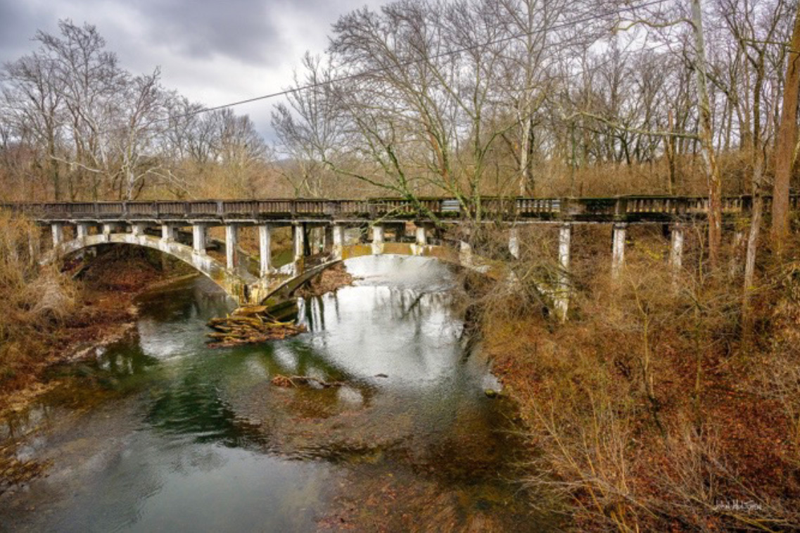
Abandoned Shelbyville Road Bridge
East of Bircham Road in the 1500 block of Shelbyville Road, Louisville
This is an abandoned bridge along a section of abandoned federal highway. It is alongside the replacement U.S. 60 highway and it can be photographed from the new highway bridge along the relocated replacement highway.
18 GPS: N 38°12.9443', W 085°31.9105'
Papa John's Waterfall Park
Papa John's Park
2002 Papa John's Blvd, Louisville
Papa John's Waterfall Park is at Papa John's International, Inc.'s corporate campus in Louisville, and is known for its waterfall, paved walking paths, and picnic areas. It is a charming and photogenic area that features 2 waterfalls, as well as a few ponds and benches. The waterfall is man-made, a feature on the landscaped grounds of the corporate campus, designed to be an attractive and soothing element of the environment. Papa John's Waterfall Park is a public park and fishing lake that is open 24-hours. There is no charge to visit Papa John's Waterfall Park, as it is an amenity at the company's headquarters, and the area is generally open to the public. Access can be limited at times and visitors should be mindful of the location's primary purpose and follow any posted rules. You can take photos for personal use at the park, but for professional or commercial photography, specific rules may apply.
19 GPS: N 38°06.9521', W 085°31.9688'
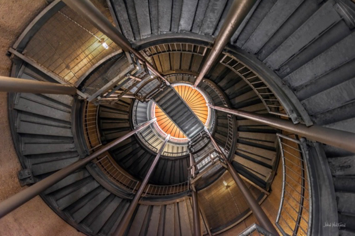
Brown Forman Silo Center
Brown-Forman Silo Center, Turkey Run Park, The Parklands of Floyds Fork
8703 Stout Rd, Louisville
The Brown-Forman Silo is located at the Brown-Forman Silo Center in Turkey Run Park, which is part of The Parklands of Floyds Fork. Thanks to a donation from the Brown-Forman Corporation, this former dairy farm has been retrofitted into a community event space containing a number of sites — the Pignic Barn, the Farmer’s Table, Hockensmith Barn, and the Silo Lookout. Standing 60 feet tall, the Silo Lookout commands views of a landscape checkered into fields and hickory groves and mazes of bike trails.
There is no fee to visit the Brown-Forman Silo Center. Turkey Run Park is part of The Parklands of Floyds Fork, a donor-supported public park system where there is no entrance fee for general access. Free parking is available. Casual and personal photography is allowed, and no permit is needed for personal use. However, a commercial activity permit is required for professional photography, or for any photography that involves charging participants, such as wedding photographers.
This photo was taken at the entrance at the base of the silo, while lying on the ground looking up. However, there is a scenic lookout at the top of the stairs.
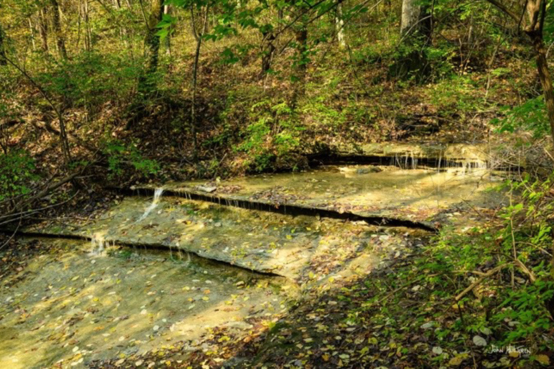
20 GPS: N 38°05.5644', W 085°32.7967'
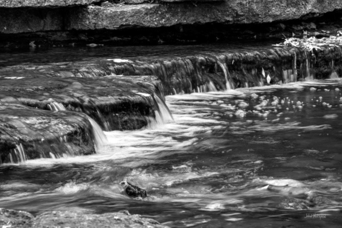
Broad Run Park Karst Climb Trail Waterfall
Broad Run Park
The trail entrance is around 9468 Broad Run Rd, Louisville
The Karst Climb Trail is a wooded, approximately 1-mile-long trail in Broad Run Park within The Parklands of Floyds Fork near Louisville, popular for its challenging, natural surface for hiking and biking. It connects to other trails, such as the Louisville Loop and the Highlands Crossing Trail, making it part of a larger network. The entire loop is 3.1 miles and is rated Easy. Hikers and bikers will find multiple cascading waterfalls along the trail, especially after rain.
There is no fee to visit Broad Run Park, which is part of The Parklands of Floyds Fork, a donor-supported public park system where there is no entrance fee for general access. Free parking is available. Casual and personal photography is allowed, and no permit is needed for personal use. However, a commercial activity permit is required for professional photography, or for any photography that involves charging participants, such as wedding photographers.

 ADVERTISEMENT